
Significant Scientific Results from Phase II of the Meridian Project Presented at the SuperDARN International Conference
On May 20, 2024, the International SuperDARN Conference was inaugurated at the Beijing International Conference Center. At the conference, one of the major equipment of the 13th Five-Year Plan’s National Major Scientific and Technological Infrastructure "Space Environment Ground-Based Comprehensive Monitoring Network" (Meridian Project Phase II), the Northern Mid-Latitude HF Radar Network, released its first batch of scientific detection results. This marks a new breakthrough for China in HF coherent scattering radar technology and scientific research and signifies the advancement of high-level international cooperation.
The detection results include observations from May 10, 2024, during a major geomagnetic storm, with the Longjing West HF Radar at Wave Position 15. The results reveal approximately one hour of shortwave attenuation caused by a solar flare and the rapid drift of numerous small-scale ionospheric irregularities.
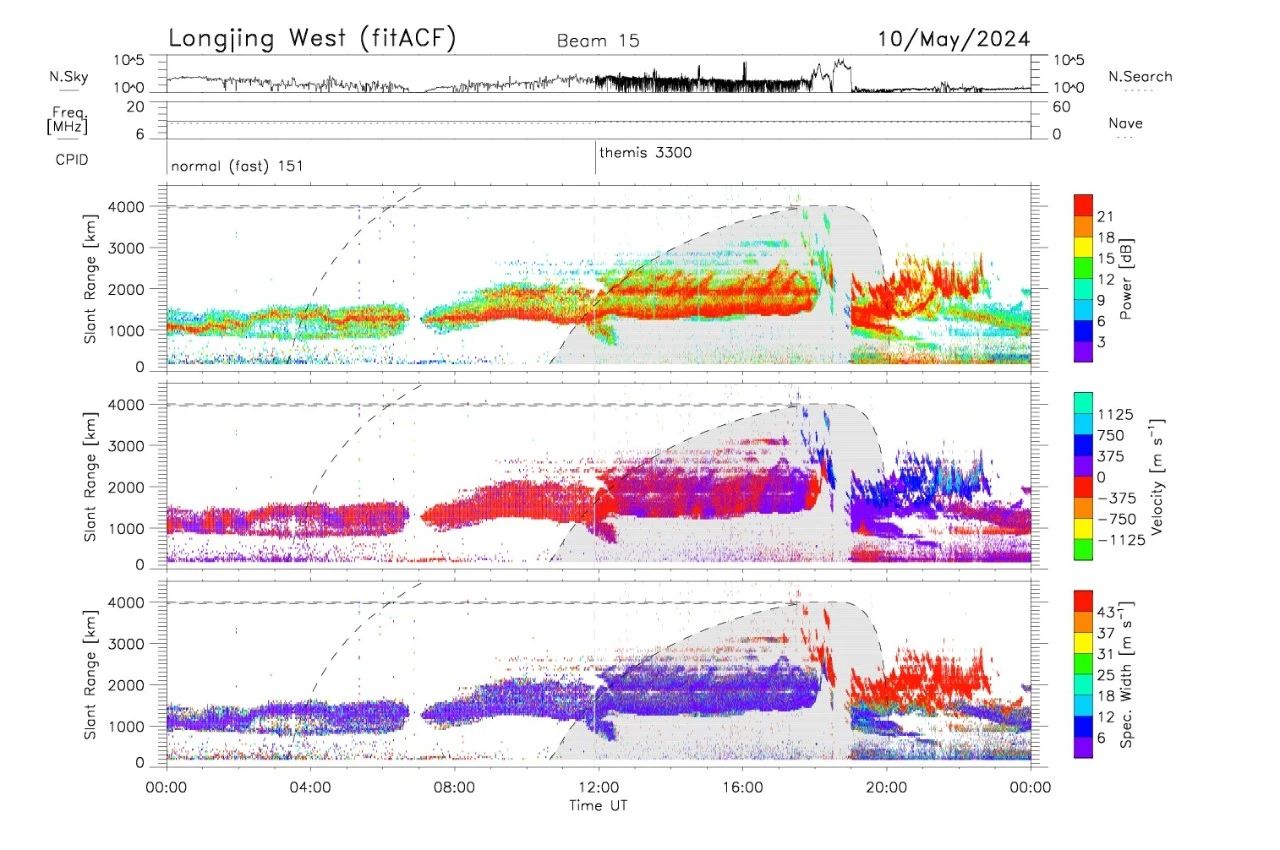
Figure 1 Detection results from the Longjing West HF Radar at Wave Position 15 during the major geomagnetic storm on May 10, 2024
The Northern Mid-Latitude HF Radar Network is China's first high-frequency coherent scattering radar detection network, led by the National Space Science Center of the Chinese Academy of Sciences. The network consists of three stations with six HF coherent scattering radars, located in Longjing City, Jilin Province in the east, Siziwang Banner, Inner Mongolia in the center, and Hejing County, Xinjiang in the west. The detection range extends up to 4000 kilometers to the north and spans over 10,000 kilometers east to west, covering a vast area of the northern geomagnetic latitudes of 40° to 80° in the Eurasian sector. This network represents the world's first large-scale, high-precision continuous detection of the mid-high latitude ionosphere in the Eurasian sector.
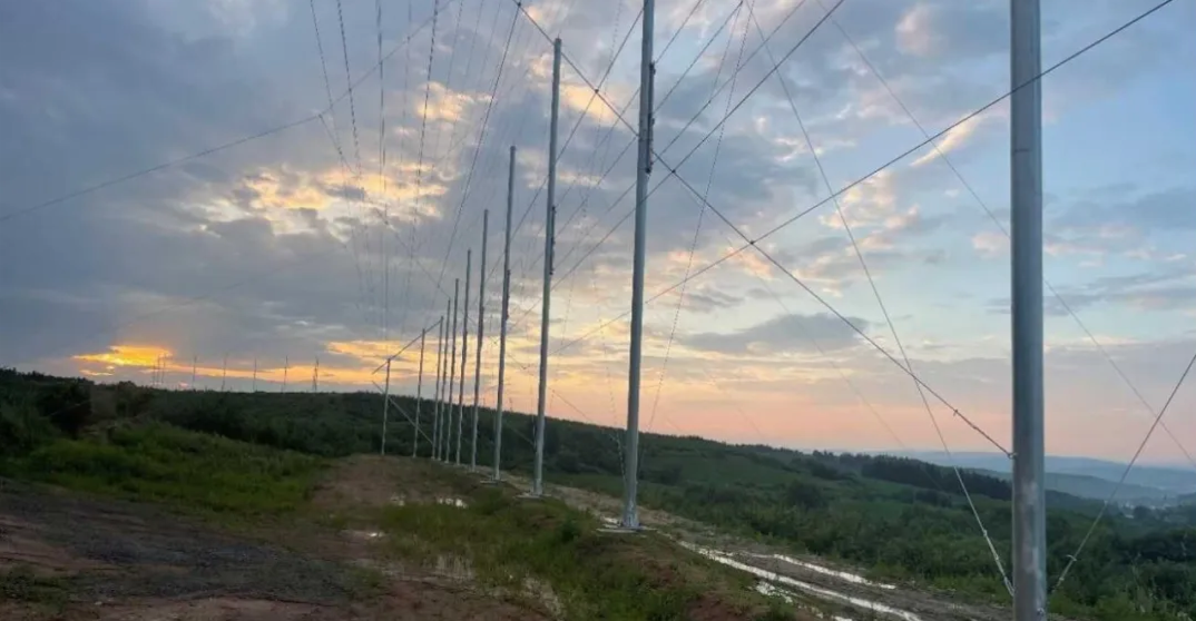
Figure 2 Jilin Longjing Station
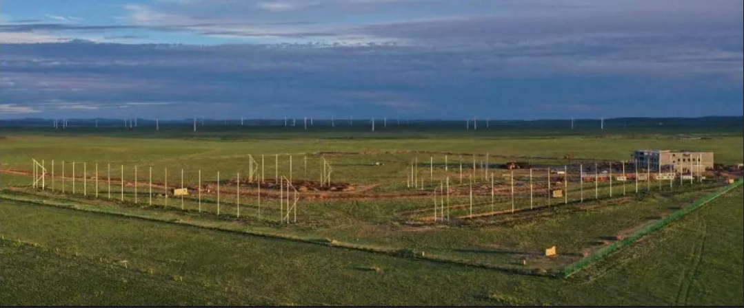
Figure 3 Panorama of Siziwang Banner Station, Inner Mongolia
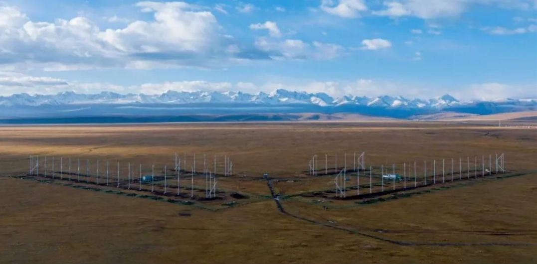
Figure 4 Panorama of Hejing Station, Xinjiang
China's Northern Mid-Latitude HF Radar Network will serve as a bridge connecting the Earth's polar regions and the domestic monitoring network of the Meridian Project. It will play a crucial role in studying the characteristics of the ionosphere and the propagation and coupling of ionospheric disturbances across high, middle, and low latitudes. Additionally, it will effectively fill gaps in the international SuperDARN network, significantly enhancing the network's global ionosphere detection range and capability. This network will provide high-quality detection data for global space weather forecasting and early warning, reflecting China's commitment to building a shared future for humanity in outer space and contributing to the peaceful use of outer space.
In accordance with the "construction, operation, and output" principle of the Meridian Project Phase II, the Northern Mid-Latitude HF Radar Network was fully constructed by October 2023 and has passed the technical acceptance by the Chinese Academy of Sciences. After the Meridian Project Phase II passes national acceptance in 2024, it will officially join the SuperDARN network. Relying on the HF radar detection data from China, the SuperDARN-China international mirror station, operated and constructed by the National Space Science Center of the Chinese Academy of Sciences, is one of the three major databases of the SuperDARN organization. It enables real-time data exchange and sharing with databases in the UK and Canada, effectively enhancing the resilience of the SuperDARN database, as well as the efficiency of data collection, distribution, and publication.
SuperDARN is an international collaborative organization composed of over thirty high-frequency coherent scatter radars from more than ten countries around the world. The organization's members currently include more than ten universities and research institutions from countries such as the UK, the US, Canada, Japan, China, France, Italy, Norway, Australia, and South Africa. Through international cooperation and data sharing, SuperDARN achieves continuous global monitoring of the ionospheric environment using a dense network of high-frequency coherent radars deployed worldwide. The high-resolution global ionospheric irregularity movement and distribution information obtained has significant applications in fields such as communication, navigation, positioning, and over-the-horizon radar detection. SuperDARN is also one of the main international collaborators in the International Meridian Circle Program (IMCP), a major international scientific initiative proposed and led by China.
The SuperDARN conference is held annually and is a highly influential international meeting in the field of space physics. It has been successfully hosted over thirty times in more than ten countries globally. This year's conference, organized by the National Space Science Center of the Chinese Academy of Sciences, included participants from seven countries' SuperDARN member institutions, as well as engineers and scientists from the global ionospheric observation field. The successful hosting of this conference has further promoted international cooperation in high-frequency radar technologies and science and highlighted the influence and voice of China's high-level research institutions within relevant international organizations.
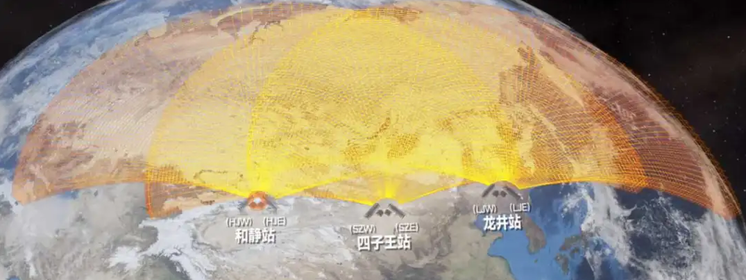
Figure 5: Detection Range of the Northern Mid-Latitude HF Radar Network
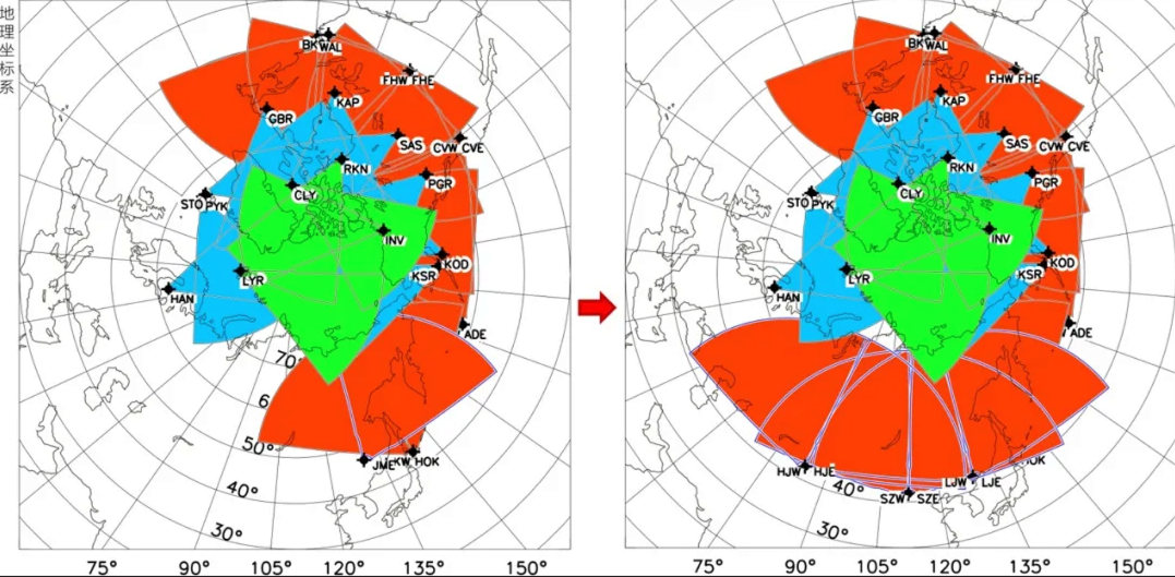
Figure 6: The addition of the Northern Mid-Latitude High-Frequency Radar Network will effectively fill the gap in the international SuperDARN observation network
Left Image: Radar field of view coverage of SuperDARN in the Northern Hemisphere.
Right Image: Radar field of view coverage of SuperDARN in the Northern Hemisphere after the addition of the six high-frequency radars from the Meridian Project